Mars Rover Panoramas Reveal Ancient Water Worlds: Curiosity and Perseverance Offer Stunning New Views
New panoramic images from NASA's Curiosity and Perseverance rovers offer a breathtaking glimpse into Mars's watery past. The sweeping vistas, captured by the rovers' high-resolution cameras, show dramatically different terrains that were shaped by ancient water flows and billions of years of geological activity. These panoramas are not just beautiful—they are scientific gold mines, helping researchers understand how environments on the Red Planet evolved over time.
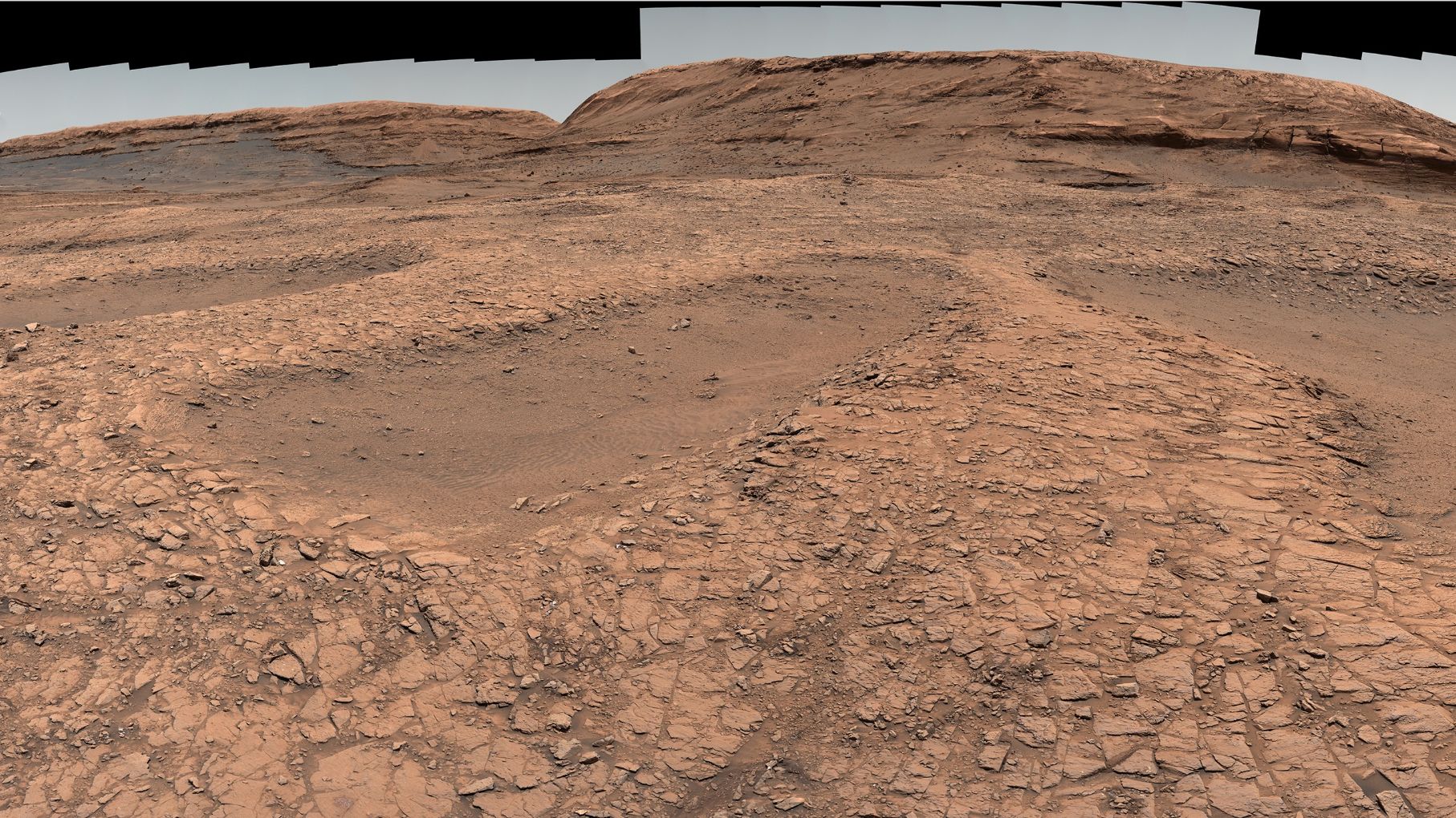
Curiosity's View: The Layered History of Gale Crater
Since landing in 2012, Curiosity has been exploring Gale Crater, a 96-mile-wide basin that once contained a vast lake. The new panorama from the rover’s Mast Camera (Mastcam) shows the rugged terrain of Mount Sharp, a central peak that rises 3.4 miles above the crater floor. The image reveals layered sedimentary rocks that were deposited over millions of years, evidence of a long-lived lake environment.

Evidence of Ancient Water
The panorama highlights features like clay and sulfate minerals, which form in the presence of water. By studying these layers, scientists can piece together a timeline of wet and dry periods on early Mars. The rover is currently climbing the lower slopes of Mount Sharp, and each new image provides clues about the planet's transition from a warmer, wetter world to the cold desert it is today.
One striking area in the panorama is the Glen Torridon region, rich in clay minerals that can preserve organic compounds. Curiosity's instruments have already detected ancient organic molecules there, though their origin remains unknown.
Perseverance's Vista: The River Delta of Jezero Crater
On the other side of the planet, Perseverance is exploring Jezero Crater, a 28-mile-wide basin that once held a lake and a fan-shaped river delta. Its latest panorama, taken by the Mastcam-Z instrument, shows the delta in stunning detail—sedimentary rocks that were carried and deposited by a river billions of years ago.
A Prime Spot for Life's Remains
Jezero was chosen as Perseverance’s landing site precisely because of its delta, which is an ideal location for preserving signs of ancient microbial life. The panorama reveals cross-bedded sandstones and mudstones, layers that indicate changing water flow and depth. The rover is now collecting rock and soil samples that will eventually be returned to Earth by a future mission—the Mars Sample Return campaign.
The images also show the delta’s edge, where the rover recently drove, and the distant rim of Jezero Crater. The varying colors in the rocks hint at different mineral compositions, some of which are associated with habitable environments.
Geological Time Capsules: Two Very Different Martian Histories
Together, the panoramas from Curiosity and Perseverance illustrate how diverse Mars's geological history is. While both craters were once filled with water, their stories diverge:
- Gale Crater (Curiosity): A long-lived lake that experienced multiple wet-dry cycles, preserving a thick stack of sediment layers.
- Jezero Crater (Perseverance): A lake that was fed by a river and drained by a delta, with evidence of catastrophic flooding that reshaped the landscape.
These differences are key to understanding how water shaped Mars at different times and places. Both rovers are essentially reading a geological book written in rock, and each new panorama is like turning a page.
How the Rovers Capture Stunning Panoramas
Creating these panoramas is no simple task. The rovers take multiple images from different angles, which are then stitched together on Earth to create a seamless 360-degree view. The process involves:
- Image Acquisition: The rover’s camera (Mastcam on Curiosity, Mastcam-Z on Perseverance) captures dozens to hundreds of overlapping images.
- Data Transmission: The images are sent to Earth via NASA's Deep Space Network, a process that can take hours due to the vast distance.
- Stitching and Processing: Scientists at the Jet Propulsion Laboratory (JPL) and other institutions assemble the images, correct for color and lighting, and create the final panoramic product.
These panoramas serve not only as scientific data but also as a way to engage the public. The rovers offer an immersive window into an alien world, allowing anyone with an internet connection to explore Mars from their living room.
Next Steps: What's Ahead for the Rovers
Both rovers continue to push the boundaries of exploration:
- Curiosity is heading toward the sulfate-bearing unit on Mount Sharp, where scientists expect to find signs of a drying climate.
- Perseverance will soon climb onto the delta’s main fan, a region full of layered rocks that could contain the best-preserved evidence of ancient life.
The panoramas released today are a testament to the rovers' longevity and the dedication of the engineers and scientists who keep them operational. As the rovers continue their treks, they will send back even more stunning views—and with each new image, our understanding of Mars grows deeper.
For a video tour of these panoramas, including narrated flybys, visit NASA's Mars 2020 mission page or Curiosity's mission page. But even the still images speak volumes about Mars's watery past and the possibility that life once thrived there.